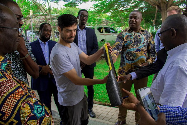
A four-member team from Forest 2020, a United Kingdom Space Agency-funded project aimed at improving forest monitoring systems, is in the country to begin the trial mapping of cocoa growing areas.
The trial exercise is part of a larger picture which includes the mapping of tree crops especially cocoa from forest, mappings of mangrove forest, burnt scars in savannah landscape, degradation assessment using earth observation application and the development of a unified forest monitoring system.
The Forest 2020 project is being implemented by a consortium of UK and international partners, including the University of Leicester, University of Edinburgh, Carbomap, Kwame Nkrumah University of Science and Technology, the Forestry Commission of Ghana and Ecometrica Ltd.
Using drones, the team will capture and develop third dimension (3D) images that will help map the cocoa-growing region in Ghana and to map accurately the difference between natural forest and shaded cocoa.
Importance
“This is important because the cocoa companies and the Government of Ghana have committed to sourcing only zero-deforestation cocoa, that is cocoa that is not linked in any way with deforestation. In order to do that they have to get that evidence which shows where cocoa is being grown and where forests are.
“They should also have means to show whether cocoa is encroaching into protected areas such as forest reserves. It would allow the Forestry Commission to detect soft spots where encroachment is going on and target those areas to ensure that the people in those areas are aware that perhaps their cocoa farms are illegal because they are encroaching into forest reserves,” the Coordinator of Forest 2020 for Ghana and Kenya, Ms Ruth Malleson, said.
Ms Malleson, however, said there had to be a very gradual step-by-step process where farmers are provided with alternative land or alternative livelihood to ensure that the project does not lead to an adverse effect on their livelihood.
“It is important that we don’t just preserve forests but also ensure that people have good income,” she said at a meeting with officials of the Forestry Commission to exchange documents and show the drone to be used for the project.
The challenges
Forest monitoring has become critical to national efforts to respond to deforestation and forest degradation. The ultimate need of forest monitoring is to use spatial tools to accurately and realistically understand the effect of land use and land use change on sustainable forest management for informed policies and interventions.
This has been the major premise upon which Ghana is pursuing the emission reduction programme and other forestry sector mitigation interventions.
Ghana is challenged by the lack of a national digital spatial infrastructure that will hold and share reliable spatial data to end users.
There are difficulties with differentiating deforestation resulting from the expansion of tree crops spatially. To date there is no conclusive way of spatially and conveniently understanding how forests cover gain is driven by crops such as cashew and mango rather than timber plantations.
The same can be said of cocoa expansion in the high forest zone.
In that regard, the Deputy Chief Executive of the Forestry Commission, Mr John Allotey, said the objectives of the project were solutions to some of Ghana’s forest management challenges.
“We need to properly map what is on the ground to measure the levels of deforestation and feed it to our REDD+ programme.
“Sometimes we spend so much time and with a lot of people on the field to get the data but with satellite imagery, in real time we will be able to obtain some of the information we need to take decisions in good time,” he said.
Although Ghana’s economy is highly dependent on cocoa, which contributes more than $2 billion annually with some 800,000 farmers earning their living from the cash crop, Mr Allotey said the country’s plan is not to increase production at the expense of the forest.
“What we are doing with cocoa is to increase the output per hectare so that a lot more land will not be put under cultivation before achieving the target set for the cocoa industry. We are employing hand pollination as well encouraging the farmers to plant more trees on the farms,” he said.
Forest 2020 is a major investment by the UK Space Agency, as part of the International Partnerships Programme (IPP), to help protect and restore up to 300 million hectares of tropical forests by improving forest monitoring in six partner countries through advanced uses of satellite data.
IPP uses satellite data to deliver measurable impact to developing and emerging economies, directly influencing 10 UN Sustainable Development Goals.
The project is running in Ghana, Brazil, Colombia, Indonesia, Mexico and Kenya.